Tááʼtsʼáadah
Contributed by Nicole Schmitz
I love this image, because it reminds me about why I love field geology and field work. Exploring a study area on foot, with the objective to understand the rocks in their natural environment and their natural relationship to one another, is a key part of geological work. As a planetary scientist, I unfortunately cannot travel to my favorite study sites in person. Instead I have to rely on robots like Perseverance to do the footwork (wheel work?), and it feels a bit like Perseverance is taking us along on the ride. Sol by sol, Perseverance investigates her surroundings with her cameras, spectrometers and tools, and we never know what she will find around the next bend.
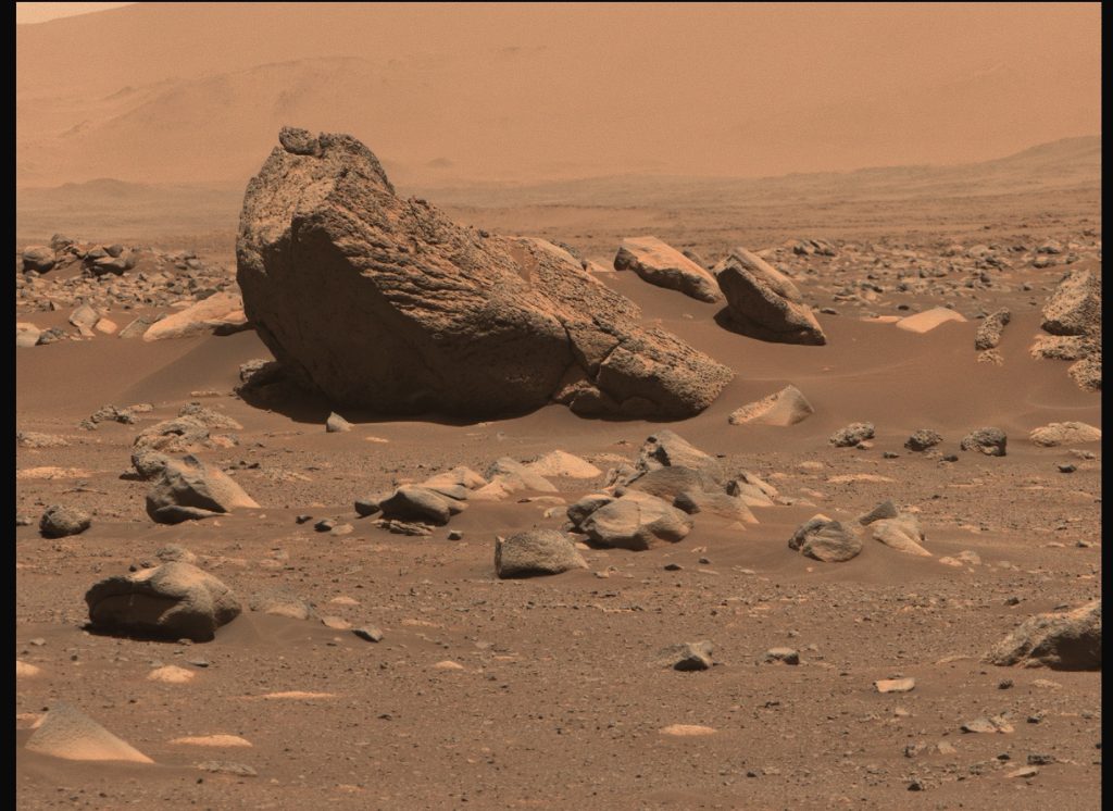
On sol 109 (June 11, 2021), Perseverance was located just east of a prominent inlier that exposes older materials of the crater floor (called Séítah, a Navajo word for ‘sand dunes’). Séítah sits between the Octavia E. Butler landing site and the exhumed front of the western delta. On her way to a good overlook location, Perseverance arrived at the rim of a small crater named Adziilii (meaning “power” in Navajo), with a good view of the blocky crater rim. In the following sols, we used Mastcam-Z to image multiple large blocks in the area, and one of them was Tááʼtsʼáadah (“13” in Navajo), located on the south-western rim of Adziilii.
One important question we have strived to answer since Sol 1 is whether the rocks we are seeing are sedimentary (like sandstone) or igneous (formed by volcanic activity). It takes many different investigations in order to answer this question, but sometimes the rock structure and texture alone give important clues. When I saw the first Mastcam-Z close-up image on Tááʼtsʼáadah with its ropey surface features and abundant vesicles, I was fascinated by what looked very much like a chunk of Pāhoehoe lava – possibly ejected/exhumed from the nearby crater. Pāhoehoe (Hawaiian for “smooth, unbroken lava”) is basaltic lava, and Pāhoehoe surfaces usually display smooth, billowing, undulating or ropy textures which are generated by very fluid lava moving under a solidifying surface crust.
For many geologists, a sight like this will trigger images of volcanic landscapes in Hawaii, because Pāhoehoe flows are an important component of Hawaiian volcanism, with tube- and surface-fed Pāhoehoe comprising major parts of Kilauea Volcano’s surface. But Pahoehoe lava sequences are also common in flood basalt terrains where I have worked on testing of future Mars rover instruments. The ropey surface textures on Tááʼtsʼáadah reminded me of steep cliffs in a very different part of the world: the remote Faroe Islands, a North Atlantic archipelago, located about halfway between Norway and Iceland.
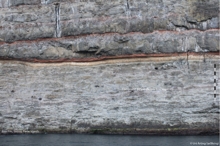
The Faroe Islands consist of a > 6 km (3.7 mile) thick sequence of flood basalts erupted during opening of the North Atlantic 55 million years ago. And parts of this sequence consist of compound Pāhoehoe flow fields made up of multiple lava flow lobes, sometimes with preserved open lava tunnels. In order to test the pahoehoe lava hypothesis for Tááʼtsʼáadah and similar textured boulders, we will need data on rock- and mineral composition and microtextures – more rover fieldwork. But the good news for me as a fieldwork-loving planetary scientist is, that looking at results from very human fieldwork on Earth can help. Studying terrestrial Pāhoehoe flows, including the Faroese ones, could tell us what to look for to support the tentative identification of such a flow on Mars with a different dataset, working under the assumption that key aspects of the formation on Mars and Earth would be analogous.
Field work in two worlds, robotic and human, to better understand both worlds.
June 11, 2021