The Science of Kodiak
Contributed by Jim Bell
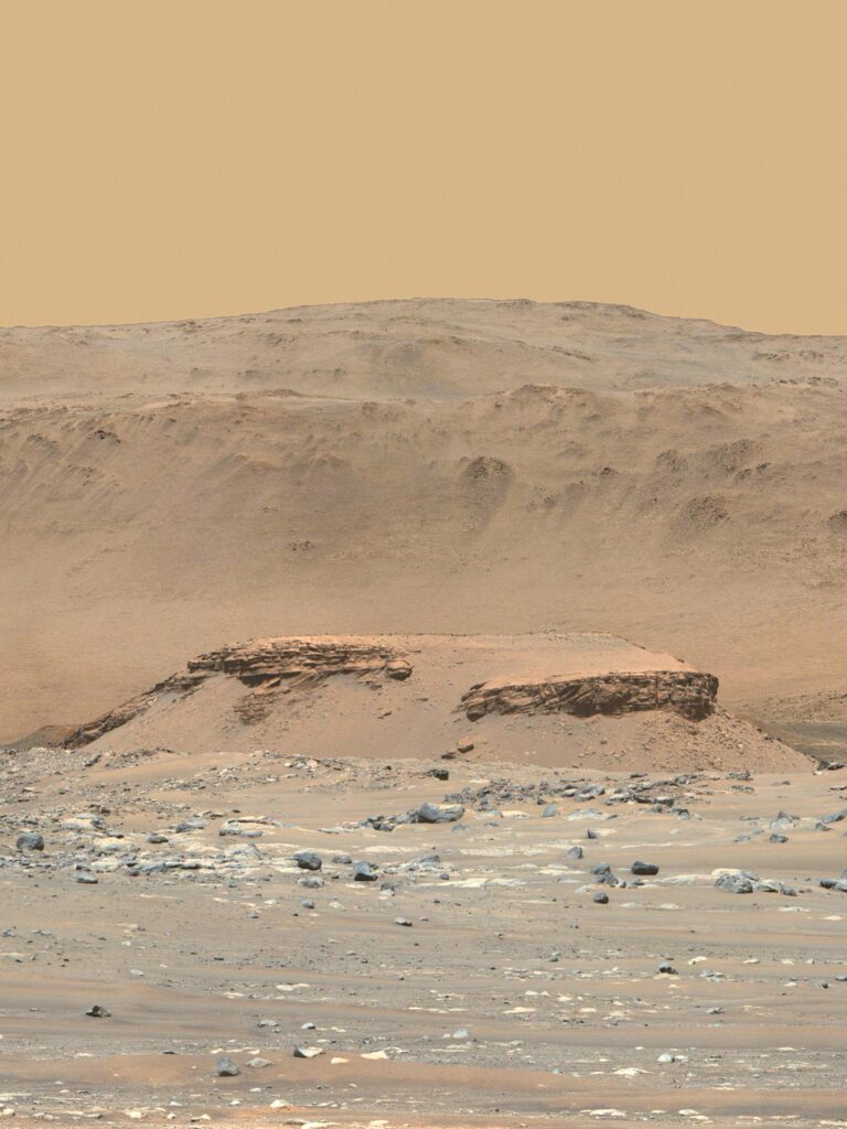
The first peer-reviewed scientific results to come out of the NASA Mars 2020 Perseverance rover’s mission were focused on the famous western delta of Jezero crater — the very geologic feature that was the main reason that Jezero crater was chosen as the rover’s landing site. In the foreground of this spectacular scene is a feature informally known as “Kodiak”, a flat-topped mesa about 500 feet (150 meters) wide and 65 feet (20 meters) tall that exhibits spectacular layered rocks. The criss-crossing of these layers, here in the isolated Kodiak delta remnant and elsewhere on and near the main delta feature, provide the “ground truth” for the interpretation of the western Jezero feature as an actual river delta — a fan-shaped deposit of riverborne sediments that were gradually deposited and built up into layers into the shallow water that once filled Jezero crater.
This photo is a mosaic of 12 images from the nearly 1000 acquired to create the first high-resolution (110-mm zoom) Mastcam-Z 360° panorama taken on the Perseverance mission — the so-called “Van Zyl Panorama” that is described in detail on this NASA/JPL Planetary Photojournal page: https://photojournal.jpl.nasa.gov/catalog/PIA24663 and on this Mastcam-Z team blog entry: https://mastcamz.asu.edu/sols-53-64-van-zyl-overlook-360-panorama-released.
This photo is one of my personal favorites because it was also used as the cover photo for the 5 November 2021 issue of Science magazine, which included the paper by Nicolas Mangold, Sanjeev Gupta, and other members of the Mars 2020 science team (including me!) that describes the delta interpretation in detail. The paper also provides exciting and enigmatic evidence for late-stage highly turbulent flooding events that transported and rounded huge boulders that can also be seen embedded in some of the delta’s uppermost layers. The full reference citation to the research paper is provided below. It can be accessed online at https://www.science.org/doi/10.1126/science.abl4051, although it is unfortunately behind a paywall and thus not available for free to general audiences.

I assembled and processed this mosaic from 12 individual 110-mm focal length images taken by the right-eye Mastcam-Z instrument aboard NASA’s Perseverance rover on mission sol 57 (April 18, 2021). Some of the special processing performed here included some slight brightening of Kodiak’s foreground layers to help bring out some of the detail, and expansion of some of the sky coverage (using surrounding sky colors) above the distant hills to fill in the parts of the sky that we didn’t image directly because the mosaic was focused on landscape coverage, not sky coverage. Kodiak is about 1.4 miles (2.2 kilometers) from the rover, and the background hills — the rim of Jezero crater itself — range from about 3.0 to 4.5 miles (5 to 7 km) in the distance.
Citation: Mangold, N., S. Gupta, O. Gasnault, G. Dromart, J.D. Tarnas, S.F. Sholes, B. Horgan, C. Quantin-Nataf, A.J. Brown, S. Le Mouélic, R.A. Yingst, J.F. Bell III, O. Beyssac, T. Bosak, F. Calef III, B.L. Ehlmann, K.A. Farley, J.P. Grotzinger, K. Hickman-Lewis, S. Holm-Alwmark, L.C. Kah, J. Martinez-Frias, S.M. McLennan, S. Maurice, J.I. Nuñez, A.M. Ollila, P. Pilleri, J.W. Rice J., M. Rice, J.I. Simon, D.L. Shuster, K.M. Stack, V.Z. Sun, A.H. Treiman, B.P. Weiss, R.C. Wiens, A.J. Williams, N.R. Williams, K.H. Williford and the Mars 2020 Science Team, Evidence for a delta-lake system and ancient flood deposits at Jezero crater, Mars, from the Perseverance rover, Science, doi:10.1126/science.abl4051, 2021.
December 24, 2021